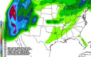
It will snow heavily tonight and all day Wednesday with snowfall rates that could exceed 3 inches per hour. Looking for 1.5-2 feet on the ground by morning and then we could double down on that during the day on Wednesday. Snow showers will continue Wednesday night with high snow to water ratios making for super light powder. By the Thursday morning snow report I am expecting storm totals of around 4-5 feet on top. The biggest 24 hour total for Alpine this winter so far was 35 inches on 11/21, and a 2-day total of 59 inches 11/20-11/21. Let’s see how this storm compares.
Snow showers will continue off and on through Thursday night adding another 6-12 inches of light powder. Then another low pressure moves in bringing steady accumulating snow Friday into Saturday. That storm could bring another 6-12+ inches. By Sunday I am expecting the 6 day totals to be in the 5-7 foot range on the mountain.
We get a break on Sunday and Monday before we start to see some smaller cold storms next week as the ridge shifts a bit East in the North Pacific. In that position the storms drop down the East side of the ridge down the coast and have less over water trajectory and less moisture to work with. Still with the really cold air in place the storms won’t need much to bring several inches of snow.
Looking long-range at the final weekend of the month and into the first week of March the teleconnections are still in a favorable pattern for the storm door to remain open. We may see the ridge redevelop further West in the NorthPacific allowingn the storms to dig again and pick up more moisture. As of right now it appears that the active pattern will continue into the beginning of March.
Stay tuned for updates on the storm……….

Comments