It looks like you are using an ad blocker. That's okay. Who doesn't? But without advertising revenue, we can't keep making this site awesome. Click the link below for instructions on disabling adblock.
Welcome to the Newschoolers forums! You may read the forums as a guest, however you must be a registered member to post.
Register to become a member today!
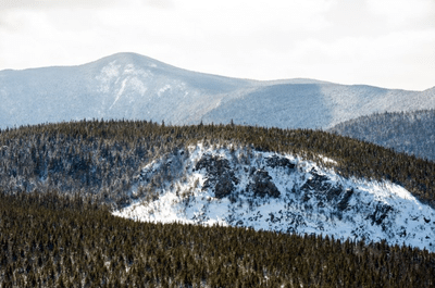
Has anyone ever skied this cliff area at Sugarloaf? I've never heard anything about it, but you can clearly see it from the bottom of the mountain and even on the trail map. It looks very rideable and there's gotta be some awesome lines down it.
It looks pretty sick to me and I'd be surprised if no one has done it. Maybe it's just too hard to get to?
Maybe lots of people ride it and are trying to keep it a secret and I'm accidentally exposing it.
Or maybe I'm just dumb and no one would ever be stupid enough to want to hike over there and ski down.
Hells gate right? I've got a poster of Seth sending off there. I'll be out to Burnt a few times this year so I'll get a better look at it at some point.
MJHarris15Hells gate right? I've got a poster of Seth sending off there. I'll be out to Burnt a few times this year so I'll get a better look at it at some point.
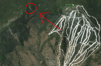
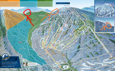
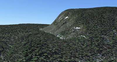
I thought that hells gate was the name of one of the trails right in the backside snowfieilds (orange arrow below). That's a sick trail too that I want to do this year. The cliff I'm talking about is further from the mountain in the far Brackett Basin area. As far as I know, It doesn't have a name and has never been skied, although I wouldn't be suprised if Seth Wescott has done it. On the trail map it seems to be shown as in-bounds territory (red arrow), but it doesn't have anything marking it as a trail.
You can see it pretty well from the top of burnt mountain, but I don't know how one could get to it or how hard it would be to get there. It's hard to see how skiable it is from so far away.
Here are some pictures of it from google earth, just for the fun of it:
- view from burnt mountain side, sugarloaf east side in background
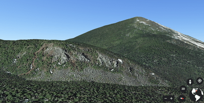
- view downhill of it, towards base of sugarloaf
Mr.LumpyjumblesI thought that hells gate was the name of one of the trails right in the backside snowfieilds (orange arrow below). That's a sick trail too that I want to do this year. The cliff I'm talking about is further from the mountain in the far Brackett Basin area. As far as I know, It doesn't have a name and has never been skied, although I wouldn't be suprised if Seth Wescott has done it. On the trail map it seems to be shown as in-bounds territory (red arrow), but it doesn't have anything marking it as a trail.
You can see it pretty well from the top of burnt mountain, but I don't know how one could get to it or how hard it would be to get there. It's hard to see how skiable it is from so far away.
Here are some pictures of it from google earth, just for the fun of it:
- view from burnt mountain side, sugarloaf east side in background
- view downhill of it, towards base of sugarloaf
Oh shit ya no, never mind me lol. I'm still gonna go check it out, but I've got no idea if it fills in enough to actually ski or not
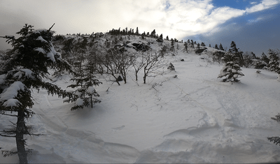
Finally went over there to take a look. Lots of rocks uncovered leaving it pretty unskiable right now, and impossible to link any turns. It's too steep and exposed for good snow coverage given the snowfall so far this year (and probably most years), but it was still fun to pick my way down a short line on the far skiers left side and hit a little drop.
It's pretty hard to get to, with a steep climb and some significant bushwhacking to get both there and back. I wasn't able to hike much higher up the hill than where I dropped in on the far (lookers) right.
Overall the hike over was pretty tricky and all the rocks make the lines essentially unskiable. Nonetheless, I was stoked to finally check it out.
I went on a very similar mission this weekend, didn't find much to ski but it's always fun to explore
Mr.LumpyjumblesUpdate:
Finally went over there to take a look. Lots of rocks uncovered leaving it pretty unskiable right now, and impossible to link any turns. It's too steep and exposed for good snow coverage given the snowfall so far this year (and probably most years), but it was still fun to pick my way down a short line on the far skiers left side and hit a little drop.
It's pretty hard to get to, with a steep climb and some significant bushwhacking to get both there and back. I wasn't able to hike much higher up the hill than where I dropped in on the far (lookers) right.
Overall the hike over was pretty tricky and all the rocks make the lines essentially unskiable. Nonetheless, I was stoked to finally check it out.
I have ALWAYS wanted to ski this cliff, but never attempted to reach it. Care to share your route to it?
Mr.LumpyjumblesHas anyone ever skied this cliff area at Sugarloaf? I've never heard anything about it, but you can clearly see it from the bottom of the mountain and even on the trail map. It looks very rideable and there's gotta be some awesome lines down it.
It looks pretty sick to me and I'd be surprised if no one has done it. Maybe it's just too hard to get to?
Maybe lots of people ride it and are trying to keep it a secret and I'm accidentally exposing it.
Or maybe I'm just dumb and no one would ever be stupid enough to want to hike over there and ski down.