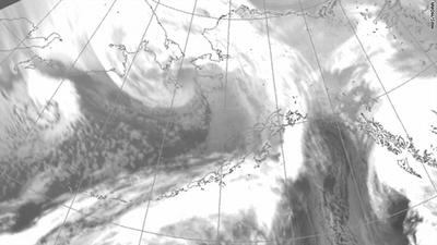
A winter storm of hurricane strength was slamming Alaska early Wednesday with winds of up to 100 mph, high seas and blizzard conditions.
The National Weather Service called the storm moving into the state off the Bering Sea "a powerful and extremely dangerous storm of record or near-record magnitude."
Are you there? Send an iReport.
[Updated at 1:10 p.m. ET] Frigid winds like those now ripping across the Bering Sea into Alaska can cause more damage than warm winds, meteorologists tell the Christian Science Monitor.
"Cold air impacts the water more and can push the momentum of the wind into the water more," meteorologist Jim Brader of the National Weather Service's Fairbanks office told the Monitor.
Brader also said the winds moving in the same direction over a distance of about a thousand miles, something that means bigger waves and more water pushed ashore, according to the Monitor report.
That means people on low-lying islands and coastal areas may face big trouble, according to the report.
In fact, the village of Point Hope points out on its website how it had to move parts of the village to a new site during the 1970s because of the effects of storm surge and erosion.
[Updated at 12:36 p.m. ET] The wind chill at Red Dog Dock south of Kivalina, Alaska, was -14.1 degrees Fahrenheit at 8 a.m. local time, according to measurements from the NOAA's National Data Buoy Center. Winds were gusting to 70 mph and the temperature was 12.6 degrees Fahrenheit. The rate of ice accertion, the process of ice building up on solid objects, was more than 15.6 inches an hour, according to the NDBC data.
[Updated at 12:16 p.m. ET] KNOM radio in Nome, Alaska, reports via Twitter that a two-foot diameter log, ice and rocks the size of fists are being blown along Front Street in the town.
[Updated at 11:28 a.m. ET] Major coastal flooding and severe beach erosion is expected along the northern and eastern shores of Norton Sound, the National Weather Service reports. Sea levels are forecast to rise 8 to 10 feet and strong winds may push ice in Norton Bay onshore through Wednesday night, forecasters say.
[Updated at 10:04 a.m. ET] A Twitter user says their mother's house in Kotzebue, Alaska, is shaking so hard in the wind that the woman fell down.
[Updated at 9:53 a.m. ET] The storm is pushing water in to Norton Sound and flooding is anticipated in communities along Alaska's western coast, National Weather Service meteorologist Scott Berg, told CNN Wednesday morning.
Water has moved up to the base of some buildings in Nome and is expected to continue to rise, Berg said. The weather service also has reports of roofs being torn off buildings by high winds in Nome, he said.
The highest gust reported in the storm so far is 89 mph in Wales, Alaska, Berg said.
The weather service has not reported any significant snow accumulation so far, but it has been snowing continuously in some areas since Tuesday, he said.
"When the snow is flying sideways, it's kinda hard to go out and see how much is falling," Berg said.
The center of the storm is pushing northward and will turn to the north-northwest later in the day, he said. Communities including Kivalina and Point Hope will see worsening conditions, according to Berg.
[Updated at 9:34 a.m. ET] The National Oceanic and Atmospheric Administration's Hydrometeorological Prediction Center reports the storm is generating waves as high as 40 feet in the Bering Sea. Wind gusts up to 83 mph in Cape Lisburne, Alaska, and 76 mph in Wales, Alaska, the agency said.
[Posted at 6:32 a.m. ET] Early Wednesday, Twitter reports said wind speeds in Nome in northwestern Alaska had reached 100 mph. That would be the equivalent of a category 2 hurricane if it occurred in the tropics. Twitter postings reported structural damage in Nome, including the roof blown off a building. Landline phones were down, according to a Twitter post.


