here we go again. another round of false hope and lies. lets just hope for the best.
http://www.accuweather.com/news-weather-features.asp?#extremes
Bastardi predicts the current El Niño will fade over the winter and will probably not play as much of a role in the overall weather pattern as one would think during a typical El Niño year.
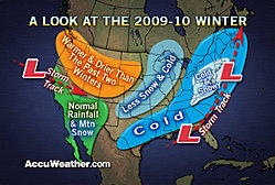
The areas that will be hit hardest this winter by cold, snowy weather will be from New England through the Appalachians and mid-Atlantic, including North Carolina. Areas from New York City to Raleigh have gotten by the past two years with very little snowfall. This year these areas could end up with above-normal snowfall.
While some parts of the Appalachians did have harsh winter weather in the form of ice last year, this winter could be one of the snowiest since 2002-03, when up to 80 inches fell in many places. Snowfall totals this year could reach between 50 and 100 inches. Last winter, the usage of salt was way up due to the number of ice storms. Salt supplies could be compromised again this year for state and local road crews that battle the winter weather. On the other hand, ski resorts could have a great year with plenty of powder for skiers.
Bastardi adds that the overall weather pattern that has prevailed this summer is pointing to a winter very similar to that of 2002-03, when major cities on the East Coast had above-average snowfall. Expert Senior Meteorologist Henry Margusity points out that in February of 2003, a major snowstorm paralyzed much of the Interstate 95 corridor, including New York City and Philadelphia. During the storm, airports were closed, roads were impassable, roofs collapsed and some schools were closed for a week, causing summer vacations to start late.
The storm track that could develop this year will bring storms up the Eastern Seaboard. This type of storm track will differ from that of the past two years, when storms tended to take a track farther west from Texas into the Great Lakes. That track into the Great Lakes brought unseasonably mild weather to the major East Coast cities, keeping them on the more rainy side of the storms. The track this year right along the Eastern Seaboard would put the major cities on the cold, wintry side of the storms.
A colder, snowier winter would mean an increase in energy bills, added snow removal efforts, more travel delays and extended school closures.
The Midwest and central Plains, which have been hit hard the past two winters, may end up with a lack of snowfall this year. Places like Chicago, Omaha, Minneapolis and Kansas City may have below-normal snowfall and could even average a bit milder than past years.
A warm and somewhat dry weather pattern is expected from the Pacific Northwest into the northern Plains. The typical barrage of winter storms that hit Seattle and Portland may not occur this winter and lead to below-normal precipitation.
The below-normal precipitation predicted for the Pacific Northwest could have "extended and severe ramifications" on the economy in a region that relies heavily on winter precipitation, according to Expert Senior Meteorologist Ken Reeves.
"A less stormy track through the Pacific Northwest, while on the surface may seem like a good thing, it is actually the opposite," Reeves said. "Winter snows supply water to the region throughout the year and also supply a significant portion of their power needs. About 70 percent of electric power generation in the Northwest comes from hydro sources."
The Olympics in Vancouver, British Columbia, from Feb. 12 to 28 could be impacted by the lack of snow and cold weather this winter.
A storm track into California and the Southwest means near-normal rainfall for Southern California. While some people across Southern California fear the El Niño will bring harsh storms to the region, the fading of the El Niño will lessen that risk and provide near-normal rainfall.


