It looks like you are using an ad blocker. That's okay. Who doesn't? But without advertising revenue, we can't keep making this site awesome. Click the link below for instructions on disabling adblock.
Welcome to the Newschoolers forums! You may read the forums as a guest, however you must be a registered member to post.
Register to become a member today!
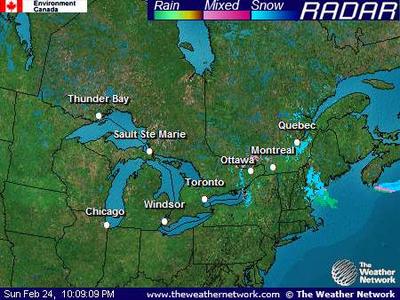
I thought it would be cool to start a thread about the weather in your area! Whats currently going on and what's up coming! There were a lot of "it's snowing" threads. (yea I am guilty of making one or two also). Thought it would be cool to start just one that everyone can update as it is happening.
Updated 6:00 AM GMT on October 08, 2007 The Jet Stream
1221 PM SNOW FAIRPLAY 39.22N 106.00W
10/14/2007 M6.0 INCH PARK CO TRAINED SPOTTER
1145 AM SNOW 2 SSE TABERNASH 39.95N 105.84W
10/14/2007 M3.8 INCH GRAND CO TRAINED SPOTTER
1145 AM HEAVY SNOW BRECKENRIDGE 39.51N 106.05W
10/14/2007 M12.0 INCH SUMMIT CO TRAINED SPOTTER
0949 AM SNOW 3 NNE BAILEY 39.43N 105.44W
10/14/2007 M3.0 INCH PARK CO TRAINED SPOTTER
0925 AM SNOW 4 WSW ELDORADO SPRINGS 39.91N 105.34W
10/14/2007 M5.0 INCH JEFFERSON CO TRAINED SPOTTER
0900 AM SNOW 1 S BRECKENRIDGE 39.49N 106.05W
10/14/2007 M8.5 INCH SUMMIT CO TRAINED SPOTTER
0817 AM SNOW 4 ENE NEDERLAND 39.98N 105.44W
10/14/2007 M4.0 INCH BOULDER CO TRAINED SPOTTER
0807 AM SNOW 6 SW EVERGREEN 39.57N 105.42W
10/14/2007 M2.0 INCH CLEAR CREEK CO TRAINED SPOTTER
0800 AM SNOW 5 SW GEORGETOWN 39.66N 105.76W
10/14/2007 M4.0 INCH CLEAR CREEK CO CO-OP OBSERVER
0800 AM SNOW 2 NNE PINECLIFFE 39.96N 105.42W
10/14/2007 M5.4 INCH BOULDER CO TRAINED SPOTTER
Tonight: Snow showers likely, mainly before midnight. Mostly cloudy, with a low around 25. Northwest wind around 7 mph. Chance of precipitation is 60%. Total nighttime snow accumulation of less than a half inch possible.
Monday: A 10 percent chance of snow before 9am. Partly cloudy, with a high near 54. West northwest wind between 5 and 8 mph.
Monday Night: Mostly clear, with a low around 23. West southwest wind between 8 and 10 mph.
Tuesday: Mostly sunny, with a high near 54. West southwest wind between 7 and 10 mph.
Tuesday Night: Mostly cloudy, with a low around 27. Southwest wind between 7 and 9 mph.
Wednesday: A chance of rain and snow showers. Mostly cloudy, with a high near 48. Chance of precipitation is 30%.
Wednesday Night: A 40 percent chance of snow showers. Mostly cloudy, with a low around 25.
Thursday: A chance of snow showers. Mostly cloudy, with a high near 40.
Thursday Night: A slight chance of snow showers. Mostly cloudy, with a low around 23.
Friday: A slight chance of snow showers. Mostly cloudy, with a high near 48.
Friday Night: Partly cloudy, with a low around 26.
Saturday: Mostly sunny, with a high near 51.
Saturday Night: A slight chance of snow showers. Mostly cloudy, with a low around 25.
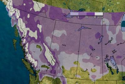
5 Day Trend..A Series Of Rather Strong And Fast Moving Fronts Will Approach The South Coast Giving Periods Of Snow To The Region Tuesday Through Thursday.
Tuesday.. Periods Of Snow. Snowfall Accumulation 5 To 10 Cm.
Freezing Level 1500 Metres.
Wednesday.. Periods Of Snow. Snowfall Accumulation 5 To 10 Cm.
Freezing Level 1250 Metres.
Thursday.. Periods Of Snow. Snowfall Accumulation 5 To 10 Cm.
Freezing Level 1000 Metres.
Snow level dropin' like a bomb^
Hopefully more snow on the way for the interior as well, it's gonna cool down here this week
So sick! Gonna drop to 750m (really low), and 10-20 cms tomorrow!
But the 14 day forcast on the weathernetwork says it's gonna get really hot in a week...
KUSA - Cool air, rain and snow will be found in the mountains and western Colorado Wednesday. Showers are possible in the east as well.
The weekend snowstorm that dropped up to a foot of new snow over parts of the northern and central mountains is long gone, but another storm is right on its heels.
Colder air rain and snow will filter into western Colorado overnight with the heaviest snowfall during the middle of the day Wednesday.
According to 9NEWS meteorologist Marty Coniglio, in the northern and central mountains 5 to 10 inches of new snowfall is expected by late Wednesday evening. For the southern mountains south of Aspen total snowfall should be in the 4 to 8 inch range.
Showers will be found in the valleys of western Colorado with the rain/snow line right around 6,000 feet in elevation.
Strong winds of 50 mph or more will be common in mountain areas Wednesday creating blinding conditions at times over the higher mountain passes.
It will be windy along the Front Range as well with 15 to 30 mph winds around the Denver area by late in the afternoon. Marty says that we may see a light shower or two, but the wind will evaporate most of what falls.
It's supposed to hit 75 today, and it's not even sunny out. It's overcast. 75 tomorrow with lots of rain and possibly severe thunderstorms, then like 58 on Saturday.
Temperatures have been mostly 15 degrees above average all fall, except for a few days where it was like 5 degrees below average.
I don't mind it now, as it keeps the Great Lakes warmer which will mean more snow when it gets cold. I just hope it does get cold by late November, and not mid-January like it did last year.
few inches of fresh snow in big sky this morning- pretty much looks like winter around here right now. its supposed to snow off and on till saturday, which would be sick
Whis is getting shitted on right now.
But it's supposed to warm up and rain for a day or two, then freezing levels skyrocket up, then maybe winter will stabilize for a while.